
The Frontier Road – A Great Trunk Road Into China -1898 to 1922
Tymon Mellor: The development of the Hong Kong road network over the years has allowed the territory to expand and develop into this sophisticated city. At the end of the nineteenth century, roads were limited to the major urban areas of Hong Kong Island and southern Kowloon. In 1898, with the extension of Hong Kong into the New Territories, the Colonial Government proposed a major road building programme, with the first new road being The Frontier Road, a link between Kowloon and Sham-Chun (Shenzhen). As reported by Mr Stewart Lockhart in the report of 8th October, 1898, “In order to facilitate the development of the country, and to render its administration easier, it is most important that proper roads should be constructed.” With the most pressing being the road from Kowloon to Tai Po and on to the Frontier.
Planning for the new road began in 1898 when initial funding was sort for the new link and an alignment was developed. The map from 1898 indicates the proposed route (shown in yellow), but given there was no topographical data available for the New Territories, (the first maps were to be published in 1904) the alignment was more a vision. However, the route followed the alignment developed from the proposed railway line, that in 1898; “appears to have been abandoned” reported Lockhart.

Before the road, the only means of access to the New Territories was by sea, a four and a half hour journey to Tai Po or by rough footpath over the 1000ft (300m) Shatin pass from Kowloon. The new road would reduce travelling times to less than two hours by bicycle and fewer than three by pony, as reported in the railway development studies. In addition to aiding the administration of the New Territories, the road was also recognised for its military benefits and as reported in 1912, “great use in facilitating the import of cattle from across the border, and from the outskirts of the Territory.”
For planning and reporting purposes (and forming the basis of the subsequent milestones) the road commenced at the Kowloon Ferry Pier, or what is now the Star Ferry and used the existing road network of Robinson Road (now Nathan Road) and then Station Street (now Shanghai Street) to proceed north. The latter was under construction in 1898 and was being extended across the tidal flats of Tai Kok Tsui. The road was to pass over the hills near Lai Chi Kok and down into the Sha Tin valley, then on to Tai Po, Fanling and Sham-Chun (now Shenzhen). As recorded on 10th June, 1899, in the Government Gazette “it will probably in time be a great trunk road into China”.
As we will see, the road was never completed as intended, but became an important means of linking the villages of the New Territories; the link with China would be served by the new KCRC railway.
The distance to the frontier with China was estimated as 22 miles from Kowloon however the road was initially estimated as being around 25 to 26 miles. The first four miles would be through the Kowloon peninsula, reaching Tai Wai at milestone nine, and Tai Po at milestone 18.
The road was designed as a 14ft (4.2m) carriage way, and initially was not surfaced, but by 1906 it was rutting as a result of the bullock carts being used to construct the new railway. A granite macadam was placed on the section between milestone 9 and 11, with the railway picking up half the cost, HK$2,750. This surfacing work was extended over subsequent years and eventually an asphalt surface was laid from the 1920’s.
Initial funding for the road was given in 1898 when HK$3,902 was allocated for the commencement of the road and further funding was approved at the Legislative Council on the 22nd March, 1900 when a sum of HK$50,000 was allocated to the “Taipo Road”. Further funding was necessary as the final cost of the 17.5 miles of road to Tai Po, was reported in 1904 as HK$233,329.95.

Existing roads made up the first 2 miles of the route, after which a new road had to be built on a 10ft (3m) high embankment across the Tai Kok Tsui tidal flats. The one mile of embankment created a brackish marsh and a new drainage channel had to be installed, requiring a bridge of two 15ft (4.5m) spans to allow the channelled water to discharged into the bay by Mong Kok Tsui.

Where the road crossed the former 1860 frontier, now Boundary Street, construction became more complex requiring cuttings and construction of rock embankments as the road started it climb. Initially a 1:20 grade was adopted as the road rose through the hills above Cheung Sha Wan to a gap in the hills at 450ft (137m). The road alignment is shown on the photograph above, taken before road construction commenced.

The road then continued to rise passing the site of the soon to be constructed Kowloon Reservoir (construction 1907 to 1910) to a summit level of 500ft (152m) before descending at a 1 in 40 grade then 1 in 30 grade into Tai Wai.
The road name, Frontier Road can be seen on the 1904 map for the section passing over the hills.
Early in 1900 the road was complete to the 9th milestone linking Tai Wai with Kowloon for the first time. The road proved popular with the local population using it to gain access to the Kowloon markets as each section was completed.
At around the fourth milestone, the road was damaged in 1907 when a large boulder slipped from the hillside nearly blocking the road. In the same year the road was washed away at the sixth milestone, when a temporary dam constructed as part of the KCRC construction works failed.

This section of the road was further improved in the 1960’s as can be seen from the photograph above.

With the growing use of motorcars, further improvements were made to the road in 1917. Between milestones five and nine, extensive realignment works were carried out (as can be seen on the map) reducing the road length by 940m.

Crossing the Shing Mun River at Tai Wai was one of the engineering challenges face by the construction team. A detailed survey was undertaken to establish flood levels along with consulting the oldest members of the village. It was decided to construct a bridge 90ft (27.4m) long, 16ft (4.8m) above the river bed to ensure there was sufficient capacity for the river. A single 90ft span would have been adopted but it was not possible to transport the heavy steel beams to the site. Given the plentiful availability of good stone, a three span bridge each of 30ft (9.1m) was adopted with two stone piers within the river. The bridge deck was then formed from rolled steel sections supporting a concrete deck. The masonry work was completed in 1900 and the steelwork shipped from London in early December, 1900.

By the end of 1900, the remaining road alignment to Tai Po had been cleared and was being used as a footpath by the villages. The route rising only 300ft (100m) was preferable to the old path that followed the telephone line and requiring a climb of 1000ft (300m).
The road to Fo Tan was opened in March, 1901 following a delay in the arrival of the bridge steel work from England necessary for the Tai Wai bridge.
During the typhoons in 1911, considerable damage was done to the road with the embankment being washed away. It was repaired and improved drainage installed to prevent future damage.
In 1920 a road widening programme commenced between Sha Tin and Tai Po along with improved alignment and new bridges to support motor vehicles.

The photograph above shows the new road alignment and bridge where a sharp bend was removed. On the left the tracks of the KCRC can be seen along with the portal to railway tunnel number three. This tunnel was removed as part of the double tracking works in the late 1970’s.
The location is just adjacent to the new roundabout at the Lai Ping Road junction, there is still a bridge across the river, but it may not be the original.

The section of road from Fo Tan to Tai Po, climbs away from the coast line and into the surrounding hills passing through a gap at 320ft (97m) before descending into Wong Nai Au. The road crossed a large river on a 120ft (36.5m) bridge followed by a causeway to the small island where the Tai Po landing pier was situated, before traversing the 2,000ft (610m) embankment, and short cutting into Tai Po village.
By the end of 1902 sufficient work had been completed on the last section of the road to allow traffic to use the route. Work had stopped on the road but it was sufficiently complete to allow villages to link with existing paths while the final cuttings and fixing of railing were completed in March, 1904. The delay in finishing the road was primarily due to difficulties with the original contractor, Chung Yung. These problems were finally overcome following his death and appointment of a new contractor in 1903 allowing completion of the final miles 14 to 17.

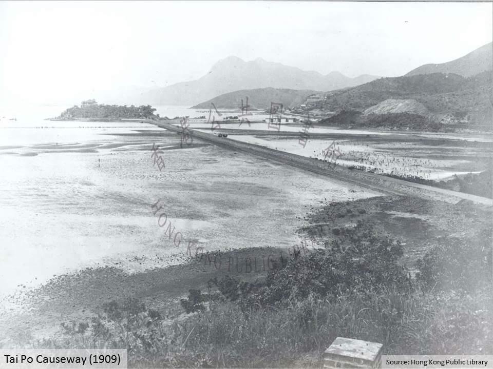
The approach to Tai Po used the existing causeway. This had been constructed in 1900 to connect the new district offices and police station with a deep water pier on the adjacent small island. The photograph above, shows the causeway and government buildings on the hill in the distance, the lower building being the (now refurbished) Old Tai Po Police Station. Funding for the causeway was given at the public works committee meeting on the 3rd January, 1900 for an estimated cost of HK$5,074. A contract was awarded in April, 1900 for HK$4,887.70 to construct the four foot (1.2m) wide causeway. During construction storms twice partially destroyed the works, delaying progress.
The causeway was subsequently strengthened and widened to carry the new Tai Po Road. By chance, the pier that the causeway was serving, was destroyed by gales in 1900 and a new pier had to be constructed in 9ft (2.7m) of water.

In 1925 the bridge connecting to the causeway, seen in the photograph above, collapsed after heavy rain. A temporary bridge was installed and a new bridge and causeway completed by November, 1927.

The new road connected into the existing local road network at the 18 mile mark. As can be seen from the 1904 map above, Tai Po consisted of a number of villages linked by roads and bridges. The main bridge, Kwong Fuk Bridge, was originally built in 1892 from stone but was too narrow for wheeled vehicles. It was replaced with a new concrete bridge in 1914 as part of the road extension to Fanling. The new bridge was 182ft (55m) long and constructed by a Mr Lam Woo.

The bridge was key to bringing the villages of the Tai Po area together, and later played a key role in the rapid advance of the Japanese army through the New Territories.

With the completion in 1913 of the link between Fanling and Castle Peak Bay (Tuen Mun) the missing section of road linking Tai Po to Fanling was started in the 1914 and completed one year later in 1915. The 4.2 miles (6.7km) of carriageway, generally followed the alignment of the recently opened railway.
After the Kwong Fuk Bridge, the road utilised the embankment originally constructed in 1906 for the KCRC railway. However, this was abandoned when the railway was realigned to the west. The road then followed the railway. Between Wai Tau and Tai Hang villages the road utilised a low embankment which had also been constructed for the KCRC but abandoned following re-alignment.
In 1916 the missing section of road through Tai Po was completed, 1,200ft (365m) linking the end of the 1904 road with Kwong Fuk Bridge and a 1915 section to Fanling at a cost of HK$2,213.

The final section of the Frontier Road, linking Fanling with the Lo Wo crossing, was never constructed. The main commercial link with China was via Shau Tau Kok, initially served with a branch line from the KCRC Fanling Station, then with the new road from 1926. With the advent of the KCRC railway and stalling development in China, there was no need for any additional road links. Thus the final leg of the road to the frontier was only completed in 1922 as a patrol path and KCRC access road.
As can be seen from the 1945 map of the frontier area, there were no roads across the border in China, and very little development along the frontier area. All this would change.

Sources:
- Report by Mr Stewart Lockhart on the Extension of the Colony of Hongkong, 8th October, 1898. http://sunzi.lib.hku.hk/hkgro/view/s1899/1610.pdf
- KCRC Route Selection Report, 11 Jan, 1905
- 150 Years of Evangelization in Taipo, http://taipo.catholic.org.hk/wp-content/uploads/2013/05/150+50_Publication.pdf
- Report on Public Works Department 1898 to 1928
- Report on the New Territories 1899 to 1926
See:
- New road linking Hong Kong with mainland China to open this month as work on HK$33.7 billion border crossing enters final stages SCMP 17th May 2019
This article was first posted on 17th June 2015.
Related Indhhk articles: