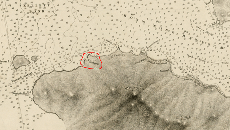
Tai Shek-ha 大石下 Stone-quarry – An 1841 hamlet near Belcher Bay, Kennedy Town?
HF: New information in red
Guy Breshears contacted me explaining he lives in Hong Kong and is working on a HK history project. He wondered if we had any information about Tai Shek-ha 大石下 Stone-quarry – A hamlet which is mentioned in a 1841 HK Census.
The first set of census results were published in the 2nd issue of H.K. Govt. Gazette, May 1841
Guy said he had not been able to find the present location of this stone quarry and he didn’t see it on the list of quarries on our website. He’s assuming it would be on HK Island.
Thomas Ngan investigated and says, “If the date of the mention of Ta Shek Ha was back then it should be somewhere on the island. I don’t have any concrete information about things that old on hand. I googled Tai Shek Ha quarry and one of the entries points to a Chinese site (http://weshare.hk/Soldier/articles/1197480) mentioning the origins of Shek Tong Tsui. They think it is likely that the neighbourhood of the mentioned quarry is there.
2. Captain Belcher marked the approximate location Tysheaha on his Map of Hong Kong Water Ways”
Thomas adds: There are a few things that I remember after reading the above article:
However, Guy says, “I checked out the census and found out that Shek Tong Tsui at that time was called Shek-tong Chuy 石塘咀.
Tai Shek-ha大石下 means “under the big rock” or something like that. But they might be in the same area together.
He says “The map isn’t great but it does give a clue to where it is. Tai Shek Ha is on the northern part of HK Island. It looks like it’s around the Wan Chai/Admiralty area. It would have to be south of Queen’s Road because everything north of it didn’t exist at the time. Also, if you look to the right of Tai Shek Ha you see 3 place names. The first is Hung Heong Loo which is the area around the Tin Hau temple near the MTR Tin Hau station.”
Congratulations to Guy’s niece for some good detective work!
Thomas: I have that book (ISBN 978-962-8930-93-7). It’s on page 13, right? But there is also a table (also in Chinese) under the map saying Tai Shek Ha (Probably somewhere in Wanchai). To me it is sort of un-confirmed and in doubt,
I would say it is still inconclusive. More digging is required.
HF: I am inclined to agree with Thomas. Further information is required to fully confirm the village and quarry location. Thanks to everyone for their efforts.
http://hongkongsfirst.blogspot.hk/ because his site has some maps on it. He wrote back saying: Hi Guy,
It’s somewhat closer to what we had a few days ago. I’m sure this will also be subject to debate.
And a contemporary Google map of approximately the same area for comparison.
Guy contacted the Civil Engineering and Development Dept. in Sept 2014. CEDD’s CK Choi responded, We are not aware of the place and quarry called Tai Shek Ha (大石下) from our records. You may find from the public domain that the name Tai Shek-ha quarry was mentioned in a conference paper entitled ‘The Licensing System for Quarrying in Hong Kong 1841 – 1941’ by S.W. Poon et al of the University of Hong Kong, which was presented at the Institute of Quarry Conference in 2011.
Guy wrote to Dr SW Poon of HKU, who replied, There are no other details about Tai Shek Ha except that it was quoted as “a hamlet for stone quarry with a population of 20 in 1841 census” (Hong Kong Gazette, No.2, 15 May 1841). The location is probably the area in between Shek Tong Tsui (Sai Ying Poon) and Belcher’s Bay. Captain Belcher’s map (1841) showed its location.
This article was first posted on 10th September 2014.
HF: We have several articles about quarrying and stone breaking in Hong Kong which are listed in the Index.


I agree that the location on the map is inconclusive mostly because it’s just a general area and nothing specific. But it does give an idea of where to look for the place. Also, as I’ve mentioned before it would have to be south of Queen’s Road because, at that time, just about everything north of that was water. More checking is indeed needed.
Guy
Hi there,
There is a link at Gwulo pointing to HKUST with a few panoramic engravings show “Hong Kong &c. as seen from the anchorage”. One of the engravings shows the Hong Kong Island towards the west. No conclusion if Tai-Shek-Ha was shown or marked on it, but you should be able to see what the artist saw. Those, according to HKUST, dated back to 1846.
http://gwulo.com/node/21153?page=0#comment-29417
Thanks & Best Regards,
Thomas